


What is BEIDOU Navigation sytem?
Key Information
- Chinese Name: Beidou 1
- English Name: Compass Satellite Navigation Experimental System
- Contractor: China Academy of Space Technology (5th Space Academy)
- Type: Navigation and positioning
- Orbit: GEO
- Launch Vehicle: CZ-3A
- Launch Site: Xichang Satellite Launch Centre
- First Launch: 31 October 2000
- Last Launch: 3 February 2007
- Satellites in Orbit: 4
- Satellites in Use: 4
Summary
The Compass Navigation Satellite Experimental System, or BeiDou 1 (BD-1) in its Chinese name, is the three-satellite constellation developed by China Academy of Space Technology (CAST). It is China's first space-based regional navigation and positioning network. The system provides all-weather, two-dimensional positioning data for both military and civilian users. The network covers most areas of East Asia region and has both navigation and communication functions. The satellite network comprises three BeiDou 1 satellites (two operational and one backup).
China began to study the satellite navigation and positioning technology as early as the late 1960s. However, development in establishing an operational satellite network has been slow due to lack of fund and technical difficulties. China first developed the "Twin-Star" regional navigation theory in the mid-1980s, and has tested it on two DFH-2A communications satellites in 1989. This test showed that the precision of the Twin-Star system would be comparable to the the publicly available signals of the United States Global Positioning System (GPS). An independent experimental satellite navigation system was given go-ahead by Chinese leaders in 1993.
The first two satellites of the BeiDou 1 navigation experimental system, the BeiDou 1A and BeiDou 1B, were launched from Xichang Satellite Launch Centre on 31 October 2000 and 21 December 2000 respectively. The system began to provide navigation and positioning services in late 2001. The third satellite (backup) BeiDou 1C was launched on 25 May 2003, bringing the system fully operational. The navigation and positioning services became available to civilian users in April 2004. This has made China the third country in world to have deployed an operational space-based navigation and positioning network.
Navigation Network
The BeiDou Satellite Navigation Experimental System covers the region between Longitude 70°~140° E and Latitude 5°~55° N. Two satellites are positioned in geosynchronous orbit at 80° E and 140° E. The third (backup) satellite is positioned at 110.5° E.
The satellites are capable of communication and horizontal positioning for China's military within their region.
The ground systems include the central control station, three ground tracking stations for orbit determination (at Jamushi, Kashi and Zhanjiang), ground correction stations, and user terminals (receivers/transmitters).
The satellites transmit at 2491.75+/-4.08MHz and the ground receiver can transmit back to the satellite on 1615.68MHz. The BeiDou reference-frame is the Beijing 1954 Coordinate System, with time referenced to China UTC as determined in Beijing.
The system provides positioning data of 100m accuracy. By using ground- and/or space-based (the 3rd and 4th satellites) differential methods, the accuracy can be increased to under 20m. The system capacity is 540,000 user per hour, and serve up to 150 users simultaneously.
Method of Operation
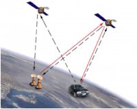
Firstly, the central control station sends inquiry signals to the users via two satellites. When the user terminal received the signal from one satellite, it sends responding signal back to both satellites. The central station receives the responding signals sent by the user from two satellites, and calculates the user's 2D position based on the time difference between the two signals. This position is then compared with the digital territorial map stored in the database to get the 3D position data, which is then sent back to the user via satellites using encrypted communications. The user can also transmit encrypted text messages (up to 120 Chinese characters) to the central station via the satellites.
Because BeiDou system requires dual-way transmissions between the user and central control station via satellites at high-altitude geostationary orbit, its user segment needs extra space for transmitter and a more-powerful battery. Therefore the BeiDou system's user segments are much bigger (20cm antenna), heavier and more expensive compared to GPS user receivers. Additionally, the number of users can be served by the system is limited by the communication capacity of the network.
Satellites
The Beidou 1 (BD-1) satellite was developed on the basis of the DFH-3 satellite bus, and is 2.2 X 1.72 X 2.0 metres in size. A pair of solar panels has a span of 18.1m. The satellite weights 2,200kg, and carries 1,100kg propellant for its main engine. Designed life span is approximately 5 years. The satellites were launched by CZ-3A launch vehicle from Xichang Satellite Launch Centre (XSLC).
BeiDou 1D (3 February 2007)
Following the three successful launches of the BeiDou 1 satellites in 2000 and 2003, a fourth GEO satellite was launched by a CZ-3A launch vehicle from Xichang Satellite Launch Centre (XSLC) at 16:28 GMT on 2 February 2007 (00:28 local time on 3 February 2007). The satellite suffered from a control system malfunction, which resulted in the solar power panel unable to expand. After some adjustment work from the ground control station, the satellite was said to be fully restored. The satellite was placed into the GEO, presumably to complement the three existing regional Beidou-1 geostationary satellites by occupying the open slots at Longitudes 58.75 degrees Ea
Reference: http://www.sinodefence.com/space/spacecraft/beidou1.asp


 Front Desk
 Louis Louis
 Elias Sahyoun
 Solange El-jbeily